
Registrations from December 17, 2025

Our signature race that will take you on the full 118km long loop over the hills and mountains around the city of Žilina.
ITRA POINTS – 5

ETC – L

UTMB INDEX – 100M


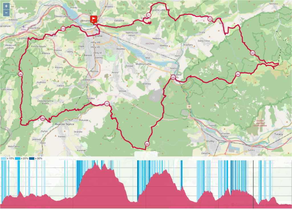
Distance: 118km – Elevation gain: 6300m – Start 19.9.2026, 6:00AM
BBU 100+ route:
Budatín Castle – Dubeň – Straník (CP1) – Kotrčiná Lúčka – Sedlo Žiarce – Lysica – Belá (CP2) – Snilovské Sedlo (CP3) – Veľký Kriváň – Malý Kriváň – Suchý – Chata pod Suchým (CP4) – Nezbudská Lúčka – Strečno (CP5) – Špicák – Sedlo Javorina (CP6) – Minčol – Pod Krížavou – Kobylie – Čipčie – Turie (CP7) – Porúbka (brod) – Skalky – Tlstá Hora – Dielnice (CP8) – Budzogáň – Žibrid – Sedlo Patúch – Kečka – Roháčske sedlo – Hrad Hričov (CP9) – Hričovské Podhradie – Ovčiarsko (CP10) – Hradisko – Strážov – Budatín
| Vzdialenosť / Distance (km) | Akumulované / Cumulative (km) | Prevýšenie / Elevation gain (m) | Akumulované / Cumulative (m) | |
| START – CP1 | 10.5 | 10.5 | 400 | 400 |
| CP1 – CP2 | 16 | 26.5 | 550 | 950 |
| CP2 – CP3 | 11 | 37.5 | 1150 | 2100 |
| CP3 – CP4 | 11 | 48.5 | 650 | 2750 |
| CP4 – CP5 | 7.5 | 56 | 50 | 2800 |
| CP5 – CP6 | 5 | 61 | 700 | 3500 |
| CP6 – CP7 | 17 | 78 | 800 | 4300 |
| CP7 – CP8 | 10 | 88 | 500 | 4800 |
| CP8 – CP9 | 15 | 103 | 1100 | 5900 |
| CP9 – CP10 | 5 | 108 | 200 | 6100 |
| CP10 – FINISH | 10 | 118 | 200 | 6300 |
Checkpoints and refreshments stations – (link):
Budatín – Zástranie – red tourist trail -> Zástranie – Straník – Zástranie – yellow tourist trail -> Zástranie – Sedlo Žiarce – red tourist trail -> Sedlo Žiarce – Lysica – yellow tourist trail -> Lysica – Belá – public road, biking trail -> Belá – Malá Bránica – yellow tourist trail -> Malá Bránica – Sedlo na koni – green tourist trail -> Sedlo na koni – Chrapáky – yellow tourist trail -> Chrapáky – Stanica lanovky – blue tourist trail -> Stanica lanovky – Snilovské Sedlo – green tourist trail -> Snilovské Sedlo – Veľký Kriváň – Strečno – red tourist trail -> Strečno – Sedlo pod Kojšovou – yellow tourist trail -> Sedlo pod Kojšovou – Sedlo Javorina – blue tourist trail -> Sedlo Javorina – Pod Krížavou – red tourist trail -> Pod Krížavou – Pod Ostrým – green tourist trail -> Pod Ostrým – Turie – blue tourist trail -> Turie – Porúbka river crossing – public road -> Porúbka river crossing – under Tlstá hora – blue tourist trail -> Tlstá hora and descent from Tlstá hora – no name trail -> below Tlstá hora reconnect to blue tourist trail all the way to Dielnice – blue trail -> Dienice – Žibrid – green trail Stratený budzogáň -> Žibrid – Pod Roháčom – green tourist trail -> Pod Roháčom – Hričovské Podhradie – Ovčiarsko – Strážov – red tourist trail -> Strážov – Budatín – public roads – final routing will be confirmed according to the road closure and renovation situation in the city at the time of the race
